 The New Mexico State Library is now providing access to digital, color versions of the New Mexico Sanborn Fire Insurance Maps from all of the library’s public computers (in-library use only). Sanborn Fire Insurance maps are accurately scaled and show street layout, building locations, and construction. According to the Historical Information Gathers (HIG), “Various governmental agencies, federal, state, county and municipal, now rely on Sanborn Maps to save costly field inspections and as a means of permanently recording valuable information from time to time. The maps are widely used by municipal and county departments such as Building, Education, Engineering, Health and Sanitation, Highway, Planning and Zoning, Public Libraries, Public Works, Sewer, Tax Assessors, Water, and City Managers”.
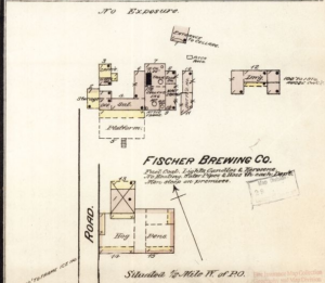
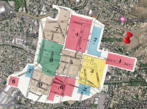
This collection of historic maps includes index maps and is searchable via interactive mapping (see image below) or by place name. Though the date range varies by location, generally the coverage is from the late 1800’s into the 1950’s. The HIG have loaded this product with features including: mark-up tools, side-by-side viewing options, detailed instructions for reading Sanborn maps, and high resolution map downloads. Color versions of Sanborn maps are a challenge to find and extremely useful for a variety of needs. We are happy to be providing access to this collection and look forward to helping you with your property research needs.
The New Mexico State Library is open to the public from 1:00 P.M. to 5:00 P.M. Monday through Friday. We are located at 1209 Camino Carlos Rey, and are available by telephone and email. 505-476-9702, reference@state.nm.us